BIDDEFORD, MAINE: Installed November 9, 2017

CHATTERMARK mural installed Biddeford, Maine: November 9, 2017, Size: 96"x174"
Pairing includes: Photogram, Beloit Glacier Ice #2 Photograph, Madgalenafjord, Graveneset Glacier, Svalbard, Norway
Images © Shoshannah White
SEA ICE SHIFT
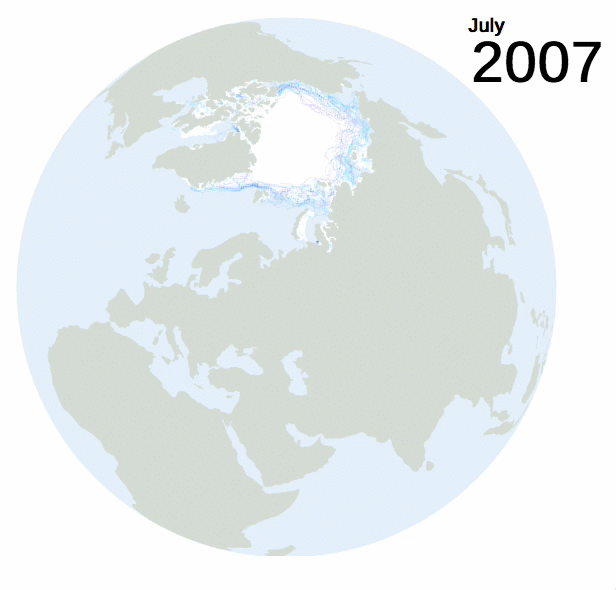
See a full rendition of cartographer Christian MilNeil's Arctic Sea Ice shifting from 1979 through 2017 here.
NASA BATHYMETRY: WATER DEPTH

Bathymetry image from NASA showing a digital image of water depth where shading shows changes in slope or depth.
Credit: Imagery by Jesse Allen, NASA's Earth Observatory, using data from the General Bathymetric Chart of the Oceans (GEBCO) produced by the British Oceanographic Data Centre.
EXCERPT by Joan Didion
I'd like to share an excerpt from Joan Didion’s The White Album, published by Simon & Schuster, 1979:
HOLY WATER
Some of us who live in arid parts of the world think about water with a reverence others might find excessive. The water I will draw tomorrow from my tap in Malibu is today crossing the Mojave Desert from the Colorado River, and I like to think about exactly where that water is. The water I will drink tonight in a restaurant in Hollywood is by now well down the Los Angeles Aqueduct from the Owens River, and I also think about exactly where that water is: I particularly like to imagine it as it cascades down the 45-degree stone steps that aerate Owens water after its airless passage through the mountain pipes and siphons.
As it happens my own reverence for water has always taken the form of this constant meditation upon where the water is, of an obsessive interest not in the politics of water but in the waterworks themselves, in the movement of water through aqueducts and siphons and pumps and forebays and afterbays and weirs and drains, in plumbing on the grand scale. I know the data on water projects I will never see. I know the difficulty Kaiser had closing the last two sluiceway gates on the Guri Dam in Venezuela. I keep watch on evaporation behind the Aswan in Egypt. I can put myself to sleep imagining the water dropping a thousand feet into the turbines at Churchill Falls in Labrador. If the Churchill Falls Project fails to materialize, I fall back on waterworks closer at hand -- the tailrace at Hoover on the Colorado, the surge tank in the Tehachapi Mountains that receives California Aqueduct water pumped before -- and finally I replay a morning when I was seventeen years old and caught, in a military-surplus life raft, in the construction of the Nimbus Afterbay Dam on the American River near Sacramento. I remember that at the moment it happened I was trying to open a tin of anchovies with capers. I recall the raft spinning into the narrow chute through which the river had been temporarily diverted. I recall being deliriously happy.
I suppose it was partly the memory of that delirium that led me to visit, one summer morning in Sacramento, the Operations Control Center for the California State Water Project. Actually so much water is moved around California by so many different agencies that maybe only the movers themselves know on any given day whose water is where, but to get a general picture it is necessary only to remember that Los Angeles moves some of it, San Francisco moves some of it, the Bureau of Reclamation's Central Valley Project moves some of it and the California State Water Project moves most of the rest of it, moves a vast amount of it, moves more water farther than has ever been moved anywhere. They collect this water up in the granite keeps of the Sierra Nevada and they store roughly a trillion gallons of it behind the Oroville Dam and every morning, down at the Project's headquarters in Sacramento, they decide how much of their water they want to move the next day.
They make this morning decision according to supply and demand, which is simple in theory but rather more complicated in practice. In theory each of the Project's five field divisions -- the Oroville, the Delta, the San Luis, the San Joaquin and the Southern divisions -- places a call to headquarters before 9 AM and tells the dispatchers how much water is needed by its local water contractors, who have in turn based their morning estimates on orders from growers and other big users. A schedule is made. The gates open and close according to schedule. The water flows south and the deliveries are made. In practice this requires prodigious coordination, precision, and the best efforts of several human minds and that of a Univac 418. In practice it might be necessary to hold large flows of water for power production, or to flush out encroaching salinity in the Sacramento-San Joaquin Delta, the most ecologically sensitive point on the system.
In practice a sudden rain might obviate the need for a delivery when that delivery is already on its way. In practice what is being delivered here is an enormous volume of water, not quarts of milk or spools of thread, and it takes two days to move such a delivery down through Oroville into the Delta, which is the great pooling place for California water and has been for some years alive with electronic sensors and telemetering equipment and men blocking channels and diverting flows and shoveling fish away from the pumps. It takes perhaps another six days to move this same water down the California Aqueduct from the Delta to the Tehechapi and put it over the hill to Southern California.
"Putting some over the hill" is what they say around the Project Operations Control Center when they want to indicate that they are pumping Aqueduct water from the floor of the San Joaquin Valley up and over the Tehechapi Mountains. "Pulling it down" is what they say when they want to indicate that they are lowering a water level somewhere in the system. They can put some over the hill by remote control from this room in Sacramento with its Univac and its big board and its flashing lights. They can pull down a pool in the San Joaquin by remote control from this room in Sacramento with its locked doors and its ringing alarms and its constant print-outs of data from sensors out there in the water itself. From this room in Sacramento the whole system takes on the aspect of a perfect three-billion-dollar hydraulic toy, and in certain ways it is. "LET'S START DRAINING QUAL AT 12:00" was the 10:51 AM entry on the electronically recorded communications long the day I visited the Operations Control Center. "Quail" is a reservoir in Los Angeles County with a gross capacity of 1,636,018,000 gallons. "OK" was the response recorded in the log. I knew at that moment that I had missed the only vocation for which I had any instinctive affinity: I wanted to drain Quail myself.
Not many people I know carry their end of the conversation when I want to talk about water deliveries, even when I stress that these deliveries affect their lives, indirectly, every day. "Indirectly" is not quite enough for most people I know. This morning, however, several people I know were affected not "indirectly" but "directly" by the way water moves. They had been in New Mexico shooting a picture, one sequence of which required a river deep enough to sink a truck, the kind with a cab and a trailer and fifty or sixty wheels. It so happened that no river near the New Mexico location was running that deep this year. The production was therefore moved today to Needles, California, where the Colorado River normally runs, depending upon releases from Davis Dam, eighteen to twenty-five feet deep. Now. Follow this closely: Yesterday we had a freak tropical storm in Southern California, two inches of rain in a normally dry month, and because this rain flooded the fields and provided more irrigation than any grower could possibly want for several days, no water was ordered from Davis Dam.
No orders, no releases.
Supply and demand...

The above "Hydro Hierarchy" map by ESRI shows the largest rivers in the continental United States. Here's a link to the interactive version where you can activate a display of the upstream (green) and downstream (red) river connections. This is an ESRI hydrographic dataset with flow information derived from 2,000 USGS stream gauge data.